
With three weeks in Iceland, you can take your time exploring Route 1 and its side trips: volcanoes, glaciers, fjords, hot springs, dozens of waterfalls, and almost constant daylight in the summer. From the lush south to the lava deserts of the north, from the fjords of the east to the cliffs of the west, every day offers a new landscape.
We’ve designed this 21-day road trip itinerary to explore Iceland in all its diversity, at a pace that leaves room for the unexpected. Here is our day-by-day itinerary, tested on-site, to help you plan your trip. No need for a 4WD.
This opinion is completely independent, based on our experiences. We visited the region anonymously, making our own choices and paying our bills in full.
3-Week Itinerary in Iceland: Our Picks
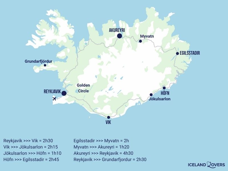
This tour circles the island counterclockwise, starting from Keflavík Airport. It covers a wide range ofattractions. Distances in Iceland are considerable: expect long days of driving, especially in the East and the West Fjords. The great thing about summer is that the sun barely sets, giving you plenty of daylight hours. We have balanced:
- nature, geology, Viking history, and contemporary culture
- as well as some busy days on the road and shorter days to enjoy the local sights.
If you have a little less than 3 weeks (such as 20, 19, 18, or 17 days), you can easily:
- Day 2 (Reykjanes Peninsula)
- Remove on day 8
- withdraw on day 13
- Remove days 14 and 15 (Western Fjords)
- Repeat on day 18 (Silver Circle)
- Day 20 (guided tour to the Central Highlands)

It’s time to book!
Compare everything: companies, prices, schedules and availability.
Practical Tips for a Road Trip in Iceland
What type of car?
This route is designed for a standard passenger car (2WD). Almost the entire route follows paved roads. There are a few unpaved sections (Stokksnes, some roads in the West Fjords), but they are still accessible to a standard vehicle in summer during dry weather.
An SUV or 4WD isn’t necessary for this tour, but it offers a more comfortable ride on gravel roads. We recommend that you reserve your vehicle several months in advance: demand is high during the summer, and rates rise quickly.
See the offers on our favorite booking platform.

Driving in Iceland
Route 1 (Ring Road) is in good condition along most of its length. On the other hand, as soon as you turn onto side roads, the road surface often becomes gravel. We found driving in Iceland to be pleasant overall: there was little traffic outside Reykjavík, and the scenery kept changing, never becoming monotonous.
Watch out for sheep crossing the road without warning between June and September, for strong winds that can cause the vehicle to swerve, and for single-lane sections on bridges.
Gas and Refueling
Gas stations are plentiful along Route 1, but they become fewer and farther between in the West Fjords and the far east. We recommend filling up as soon as the fuel gauge drops to half, especially before driving through remote areas. Many stations operate on a self-service basis with payment by credit card (PIN required).
RENTING A CAR IN Iceland
Discover the best offers on Discovercars, our preferred platform!
On Route 1, no 4WD required, off Route 1, it depends on your plans.

Day 1 – Arrival in Keflavík and Reykjavík
Total travel time: about 50 minutes
The first day of your Icelandic road trip. After picking up your rental car at Keflavík International Airport, head toward Reykjavík. Depending on your arrival time and how tired you are, you can start with a thermal bath (though it’s a bit of a detour) or by exploring the capital. We suggest you plan this first day around your flight.
Stop 1 – Thermal Lagoon: Blue Lagoon

Iceland has several developed thermal lagoons near Reykjavík. The Blue Lagoon, located on the Reykjanes Peninsula between the airport and the capital, is the most famous: its milky turquoise waters, rich in silica and minerals, reach temperatures of 37 to 40°C. Reservations are required, and slots fill up quickly in the summer.
We enjoyed the rejuvenating effect of a hot bath after our flight—a gentle way to start our stay. Book your experience
Stop 2 – Downtown Reykjavík
Iceland’s capital, the northernmost capital in the world, is easy to explore on foot. Hallgrímskirkja Church, whose concrete facade is inspired by basalt columns, towers over the city from its hilltop location. The elevator takes you to the top of the bell tower, where you can enjoy a view of the city’s colorful rooftops, the harbor, and the surrounding mountains.

On the waterfront, Jón Gunnar Árnason’s sculpture *Sun Voyager* (*Sólfar*), a stylized stainless-steel skeleton of a Viking ship, has become a symbol of the city. The old harbor is home to restaurants, shops, and the departure point for several boat tours. Nearby, the Harpa concert hall and conference center impresses with its geometric glass facade, designed by artist Ólafur Elíasson. We loved the laid-back atmosphere of Reykjavík, a city on a human scale where nature is never far away. Don’t linger too long—you’ll have a full day here at the end of your trip.
Overnight stay in Reykjavík.
View our selection of hotels or go directly to all the top-rated accommodations.
Day 2 – Reykjanes Peninsula
Total travel time: about 2 hours
The Reykjanes Peninsula, which travelers in a hurry to reach the Golden Circle often pass by, is home to some of Iceland’s most active geothermal sites.
Stop 1 – Raufarhólshellir Lava Tube
The Reykjanes Peninsula is home to several lava tunnels formed by ancient lava flows. Raufarhólshellir, which is about 1.4 km long, is one of the most accessible. A guided tour takes you underground, past solidified lava formations, mineral stalactites, and the play of colors on the walls. The temperature underground stays between 2 and 4°C all year round: be sure to dress warmly. There are other options in the area, such as Leiðarendi, which is shorter but not developed. Reservations are recommended during the summer.

Stop 2 – Seltún Geothermal Area (Krýsuvík)
Seltún is a colorful geothermal field located in the Krýsuvík area. The clay soil displays shades of yellow, orange, green, and gray, shaped by deposits of sulfur and minerals. Pools of hot mud bubble along the marked trail that winds its way between the fumaroles. The contrast between these bright colors and the black of the surrounding lava hills is striking. The tour lasts about 30 to 45 minutes. Informational signs describe the geothermal processes at work.

Stop 3 – Kerid Crater
It’s worth taking a short detour back up the Golden Circle to end the day with a visit to the Kerið crater. This volcanic crater, which is about 3,000 years old, contains a lake of intense blue-green water, framed by red and black rock walls. A trail circles the lake in 15 to 20 minutes, and a staircase leads down to the water’s edge. There is an admission fee (about 400 ISK). We enjoyed the contrasting colors at this site, which, while less spectacular than the previous ones, was still photogenic.

Overnight stay in Selfoss or along the Golden Circle. Book a 2-night stay.
See all top-rated accommodations directly.
Day 3 – Golden Circle
Total travel time: about 2.5 hours (round trip)
The Golden Circle connects three major sites on a short tour starting from Reykjavík or Selfoss. It’s Iceland’s most popular tour, and for good reason: geology, history, and the power of nature all come together in a single day. We recommend leaving early to beat the tourist buses.
Stop 1 – Thingvellir National Park
Þingvellir (Thingvellir) holds a special place in Iceland’s history and geology. It was here, in 930, that Viking settlers founded the Alþingi, one of the oldest parliaments in the world, which met outdoors for centuries. The site is also a rare geological phenomenon: the Almannagjá Fault marks the boundary between the North American and Eurasian tectonic plates. You are literally walking between two continents.
The park, a UNESCO World Heritage Site, features marked trails along the faults, the Öxarárfoss waterfall, and Lake Þingvallavatn, Iceland’s largest lake.
Allow 1.5 to 2 hours for the tour.
You can also plan a dive in the Silfra fissure! Book your excursion to Silfra!

Stop 2 – Geysir Geothermal Area
The Haukadalur Valley is home to the geyser that gave its name to all the geysers in the world: Geysir. This one is rarely active these days, but its neighbor, Strokkur, erupts every 5 to 10 minutes, shooting a column of boiling water up to 20 or 30 meters high.
The sight is mesmerizing: the blue water bubble that forms just before the eruption lasts only a fraction of a second. All around, colorful hot springs and steam vents complete the scene.

Stop 3 – Gullfoss Waterfall
Gullfoss is one of Iceland’s most powerful waterfalls. The Hvítá River plunges down two drops into a narrow canyon, creating a constant curtain of spray. On a sunny day, a rainbow forms in the mist. Viewing platforms at various levels allow visitors to get as close as possible to the waterfall.
We recommend the lower platform to really feel the power of the water: the roar is so loud that you have to raise your voice to be heard. Be sure to bring waterproof clothing; the sea spray gets visitors thoroughly soaked.

Second night in Selfoss or along the Golden Circle.
See all top-rated accommodations directly.
OUR GUIDE TO PLANNING A Dream trip
- 8 maps that make planning easier
- + 100 pre-selected locations
- Practical advice
- + 130 photos to help you choose
Day 4 – Heading south: iconic waterfalls and a black sand beach
Total travel time: about 2 hours and 30 minutes
This day takes in some of Iceland’s most photographed landscapes. The south coast features a succession of waterfalls, cliffs, and black-sand beaches that will keep your camera busy nonstop. We consider this day to be one of the highlights of the trip.
Stop 1 – Seljalandsfoss Waterfall
Seljalandsfoss is notable for a rare feature: a path allows visitors to walk behind the curtain of water, a 60-meter waterfall that plunges from an overhanging cliff. The view from behind, through the liquid veil, is striking. The ground is slippery and there is heavy sea spray: hiking boots and a waterproof jacket are essential. In the summer, the evening light there is especially beautiful.

Stop 2 – Gljúfrabúi
Just a few hundred meters from Seljalandsfoss, Gljúfrabúi is a waterfall hidden inside a rocky cave. To reach it, you have to squeeze through the walls of a narrow canyon and cross a small stream. The reward: a 40-meter drop that cascades into a natural amphitheater open to the sky. We loved the secluded atmosphere of this place. Be prepared to get your feet wet.

Stop 3 – Skógafoss Waterfall
Skógafoss is a waterfall 60 meters high and 25 meters wide, whose force creates a constant mist at the base of the falls. On a sunny day, a rainbow appears in the sea mist. A staircase with 370 steps on the right side leads to the top, where the view looks out over the coastal plain all the way to the ocean.
From there, a hiking trail follows the Skógá River inland, passing a series of smaller waterfalls. We suggest you hike at least the first few hundred meters of the trail above the waterfall to enjoy the view.

Stop 4 – Cape Dyrhólaey
Dyrhólaey is a volcanic headland that juts out into the Atlantic Ocean south of Vík. Its natural basalt arch, large enough for a small plane to fly through, makes it an iconic landmark of the south coast. From the lighthouse at the summit, the view stretches down to the black-sand beach below, the Reynisdrangar cliffs, and the Mýrdalsjökull glacier on the horizon. Between May and August, colonies of puffins nest on the cliffs. Access by car is via a steep but paved road.

Stop 5 – Reynisfjara Beach
Reynisfjara is Iceland’s most famous black-sand beach. Basalt columns—hexagonal columns of volcanic rock formed as lava cooled—form a geometric wall along the cliff. Facing the beach, the Reynisdrangar cliffs—three basalt pillars eroded by the ocean—rise up from the waves. According to local legend, these are trolls that have been turned to stone by the light of day.
Warning: The sneaker waves at Reynisfjara are dangerous. Signs warn visitors never to turn their backs on the ocean. We cannot stress this enough: serious accidents occur every year. Stay a safe distance from the shore.

Stop 6 – The Village of Vik
Vik i Myrdal is Iceland’s southernmost village, nestled at the foot of grassy cliffs. Its white church, perched on the hill, offers an unobstructed view of the village and the coast. The beach accessible from Vík (which is different from Reynisfjara) offers a walk with a view of the Reynisdrangar rock formations from a different angle. Vík has a few restaurants, a gas station, and convenience stores: it’s the last major stop for supplies before a long stretch of road heading east.
Overnight stay in Vík.
See all top-rated accommodations directly.

Day 5 – Fjaðrárgljúfur Canyon and Skaftafell National Park
Total travel time: about 2 hours and 30 minutes
Today, you’ll travel across the vast lava fields of Skeiðarársandur and Eldhraun, two lunar-like landscapes formed by historic eruptions. Amid carved canyons and glaciers, this day marks the transition to the southeastern part of the island.
Stop 1 – Fjadrárgljúfur Canyon
The Fjadrárgljúfur Canyon, approximately 100 meters deep and 2 kilometers long, was carved into the palagonite by the Fjaðrá River at the end of the last ice age. Its winding walls, covered in green moss in the summer, create an almost surreal setting. A trail runs along the top of the canyon for about 1 km, with several overlooks along the way. Access restrictions are sometimes put in place to protect the vegetation. We recommend spending about an hour there.

Stop 2 – Eldhraun lava fields and moss
Between Vík and Skaftafell, Route 1 crosses Eldhraun, a vast lava field covered in light green moss that is sometimes surprisingly thick. This lava flow dates back to the devastating eruption of Laki in 1783–1784, one of the deadliest in Icelandic history. The contrast between the black lava and the soft green moss stretches as far as the eye can see. There are parking areas along the road where you can stop. Don’t step on the moss: it takes decades to regrow.

Stop 3 – Skaftafell National Park (Vatnajökull)
Vatnajökull National Park, of which Skaftafell is the southern section, offers a network of hiking trails at the foot of Europe’s largest glacier. The most popular hike leads to Svartifoss (“the black waterfall”), a 20-meter waterfall framed by hanging basalt columns, whose shape inspired the architecture of Hallgrímskirkja in Reykjavík. The trail is about 5.5 km round trip (1.5 to 2 hours).
From the park’s overlooks, the view of the Vatnajökull glacier tongues, the moraines, and the black sand plains is breathtaking. We spent a whole afternoon in Skaftafell and could have stayed longer. The park’s visitor center provides trail maps and information on trail conditions.

Overnight stay in Skaftafell or along the road between Vík and Höfn.
See all the top-rated accommodations in Skaftafell at a glance.
Or spend a second night in Vik (a bit further down the road) – See all the top-rated accommodations right away.
OR head to Jökulsárlón—See all the top-rated accommodations near Jökulsárlón.
Day 6 – Glacial lagoons and Höfn
Total travel time: about 2 hours ( or longer if you spent the previous night in Vik)
The glacial lagoons of the southeast are among Iceland’s most spectacular natural sites. Icebergs that have broken off from the Breiðamerkurjökull glacier drift slowly through cold-water lakes before reaching the ocean. We consider this day to be one of the most memorable moments of the trip.
Stop 1 – Fjallsárlón Lagoon
Fjallsárlón is a glacial lagoon that is smaller and less crowded than its neighbor, Jökulsárlón. Icebergs with a bluish sheen float at the foot of the Fjallsjökull glacier tongue, which appears to plunge directly into the lake. With no crowds around, you can enjoy the silence of the place, broken only by the crackling of the ice. Zodiac and kayak are available during the season. We found Fjallsárlón to be more intimate than Jökulsárlón—a great addition if you visit both.

Stop 2 – Jökulsárlón
Jökulsárlón is Iceland’s largest and most famous glacial lagoon. Ice blocks of various sizes, some of which are several meters high, drift in a deep body of water that connects to the ocean. The colors range from white to translucent blue to black streaked with volcanic ash. Seals sometimes rest on icebergs.
Several companies offer amphibious boat, Zodiac, or kayak tours on the lagoon, allowing visitors to get up close to the icebergs. We recommend this excursion for the view it offers of the glacier front. Reserve in advance.

Stop 3 – Diamond Beach
Across Route 1 from Jökulsárlón, Diamond Beach is a black volcanic sand beach where translucent chunks of ice carried by the tide wash up. These boulders, smoothed by the water and the swell, sparkle like diamonds set against black velvet. The view varies depending on the light and the size of the stranded icebergs. We spent a long time watching the waves roll the ice blocks back and forth, a slow and silent dance.

Stop 4 – Stokksnes and Vestrahorn (weather permitting)
About 20 minutes from Höfn, Stokksnes Beach offers one of Iceland’s most photographed views: the Vestrahorn massif (454 m), a mountain with sharp ridges composed of gabbro and granophyre, is reflected in the pools of water on the black sand beach. Access is via a private road (entrance fee of approximately 900 ISK). The site is particularly photogenic at sunrise or sunset. If you’re not too tired from the day’s activities, we recommend taking this detour.

Overnight stay in Höfn.
See all top-rated accommodations directly.
Day 7 – Eastern Fjords
Total driving time: approximately 4 to 5 hours
The east coast of Iceland is the least-visited part of Route 1. The road winds from one fjord to another, winding its way through rugged mountains, fishing villages, and coastal vistas. The pace slows down, distances grow longer, and human encounters become rarer. We enjoyed this shift to a more intimate setting, far from the crowds in the south.
Stop 1 – Sunrise from the Höfn headland
If you’re an early riser, the promontory above the port of Höfn offers a panoramic view of Vatnajökull and the surrounding mountains. In the summer, the sun rises early and bathes the bay in golden light. A short trail accessible on foot from downtown Höfn leads to the lookout point. We went up there before breakfast, and the morning calm added to the beauty of the place.

Stop 2 – Coastal Road and Fjord Viewpoints
Between Höfn and Egilsstaðir, Route 1 winds through mountain passes, tunnels, and along the shores of fjords. The landscape alternates between cliffs plunging into the sea, black-sand beaches, waterfalls cascading down the rock faces, and lush green meadows. There are designated parking areas where you can stop to take pictures of the views.

Stop 3 – The villages of Djúpivogur and Breiðdalsvík
Djúpivogur is a small fishing port at the head of a fjord. On the pier, Sigurður Gudmundsson’s art installation “Eggin í Gleðivík” features 34 granite eggs, each representing a local bird species. The village has a few cafés and a craft shop. Further north, Breiðdalsvík lies in a steep-sided valley surrounded by colorful rhyolite mountains.

Overnight stay in Egilsstaðir. For 2 nights
See all top-rated accommodations directly.
Day 8 – Hengifoss and Seyðisfjörður
Total driving time: approx. 2h
A shorter day in terms of distance, devoted to a hike and exploring one of the most beautiful fjords in eastern Iceland. The pace is deliberately slower after the long drives of the previous days.
Stop 1 – Drive along Lagarfljót
Lake Lagarfljót, which is 25 km long and 112 m deep, is Iceland’s third-largest lake. Its opaque blue-gray waters, laden with glacial sediment, give it a unique atmosphere. Local legend claims that a serpent-like monster, the Lagarfljótsormurinn—the Icelandic cousin of the Loch Ness Monster—lives in its depths. The earliest references date back to the 14th century. You can drive along the eastern shore of the lake to reach Hengifoss Waterfall.
Stop 2 – Hike to Hengifoss
Hengifoss, at 128 meters high, is one of Iceland’s tallest waterfalls. The hiking trail (about 2.5 km, or 5 km round-trip; allow 2 to 2.5 hours) climbs steadily from the parking lot by the lake. Along the way, you’ll first pass Litlanesfoss, a waterfall framed by perfectly regular basalt columns. Further up, Hengifoss gradually comes into view: a thin stream of water cascades down a cliff face streaked with red bands of clay, alternating with layers of gray basalt.

Stop 3 – On the way to Seydisfjörður
The road connecting Egilsstaðir and Seyðisfjörður (27 km) crosses the Fjarðarheiði Pass at an elevation of approximately 620 meters. The climb crosses a mountain plateau that is sometimes snow-covered even in summer, before descending toward the fjord. From the summit, the view of the fjord below, framed by rugged mountains and waterfalls, is one of the most beautiful in Iceland. The descent itself runs alongside a series of waterfalls that cascade into the valley.

Stop 4 – The village of Seydisfjörður
Seyðisfjörður is a village of 700 residents at the head of a narrow fjord, known for its colorful Norwegian-style wooden houses and its small blue church. The main street, adorned with a rainbow-colored path, leads from the church to the harbor. Art galleries, a cultural center, and a few cafés bring the waterfront to life. We were charmed by the understated charm of Seyðisfjörður, a place that makes you want to stay a little longer.

The drive back to Egilsstaðir.
Second night in Egilsstaðir.
See all top-rated accommodations directly.
Day 9 – Dettifoss, Ásbyrgi, and Húsavík
Total driving time: approx. 3h30
A long day’s drive through northern Iceland, featuring Europe’s most powerful waterfall, a horseshoe-shaped canyon, and a converted whaling port. The landscape changes dramatically: the fjords and mountains of the east give way to desert plateaus and rock formations carved by water.
Stop 1 – Dettifoss and Selfoss
Dettifoss is considered the most powerful waterfall in Europe in terms of water flow: the Jökulsá á Fjöllum River plunges 44 meters in height and spans 100 meters in width with a deafening roar. The foam and spray are visible from a distance. The site served as the setting for the opening scene of Ridley Scott’s film “Prometheus” (2012). Access via the east shore (Route 862, paved) is the most common; the west shore (Route 864, unpaved) offers a more direct view.
About 1 km upstream, the Selfoss Waterfall (not to be confused with the town of the same name in the south) is wider and less high, forming a series of cascades set against a backdrop of black rocks. We recommend visiting both: the trail connects them in a 15- to 20-minute walk.

Stop 2 – Ásbyrgi Canyon
Ásbyrgi is a horseshoe-shaped canyon, 3.5 km long and 100 m deep, covered with a forest of birch and willow trees and wildflowers. According to Norse mythology, the canyon is said to be the hoofprint of Sleipnir, the eight-legged horse of the god Odin. The actual geological formation is linked to cataclysmic glacial floods (jökulhlaup). A trail leads to a central rocky islet (Eyjan) covered in vegetation, offering a remarkable view of the canyon walls. We found the tranquility of Ásbyrgi to be soothing after the raw power of Dettifoss.

Stop 3 – Húsavík
Húsavík is a small port town in northern Iceland, often referred to as “the whale-watching capital of Europe.” The colorful harbor, lined with wooden houses and dominated by a wooden church dating from 1907, has a remote, out-of-the-way feel. The Whale Museum (Húsavík Whale Museum), housed in a former slaughterhouse on the harbor, is one of the best in Europe on the subject. We suggest you stay in Húsavík tonight so you can enjoy the whale-watching tour scheduled for tomorrow morning.

Overnight stay in Húsavík.
See all top-rated accommodations directly.
Day 10 – Whale watching and drive to Mývatn
Total travel time: about 1 hour
By Boat and Road.
Stop 1 – Boat Tour: Whale Watching from Húsavík
Húsavík offers one of the best whale-watching rates in Iceland, especially between June and August. The tours usually last 3 hours and take place in Skjálfandi Bay. The most commonly sighted species are humpback whales, minke whales, and white-beaked dolphins. Some companies offer trips in traditional oak boats, while others use Zodiacs for a faster ride.
Book your outing in advance, especially in July and August. See options.
Be sure to bring warm clothes and a hat: the temperature at sea drops significantly, even in the summer.

Stop 2 – Drive to Mývatn
The road between Húsavík and Lake Mývatn winds through a landscape of green hills and isolated farms. In about an hour, you’ll reach the south shore of the lake. It’s one of our favorite regions, with plenty of surprising attractions.
Stop 3 – Skútustadir Pseudo-Craters
The pseudo-craters at Skútustadir, on the southern shore of Lake Mývatn, are not actual volcanic craters: they were formed when molten lava flowed over a marsh, causing steam explosions that shaped these cones. A marked trail circles the field of pseudo-craters in about 30 to 45 minutes. The rounded shapes, covered in short grass, are reflected in the calm waters of the lake. We found this walk to be gentle and contemplative—a nice prelude to the rougher landscapes of Mývatn.

Overnight stay in Mývatn. For 2 nights.
See all top-rated accommodations directly.
Or check out our article featuring our selection of the best accommodations.
Day 11 – Tour of Lake Mývatn
Total travel time: about 1 hour (round trip)
Lake Mývatn and its surroundings feature an exceptional concentration of geological features within a small area: lava formations, geothermal areas, craters, caves, and hot springs. We spent the entire day in this area, and each stop revealed a landscape that was radically different from the last.
Stop 1 – Dimmuborgir
Dimmuborgir (“the dark castles”) is a labyrinth of lava formations with jagged shapes: arches, columns, caves, and narrow passages, all sculpted by the cooling of a lava lake about 2,300 years ago. There are several marked trails of varying lengths (15 minutes to 3 hours) throughout the site. According to Icelandic folklore, Dimmuborgir is home to trolls and the 13 jólasveinar, the Icelandic “Santa Clauses” who visit children one by one during the 13 days leading up to Christmas.

Stop 2 – Hverir/Námafjall Geothermal Area
Hverir (also known as Námaskarð) is a geothermal field located at the foot of Námafjall Mountain, east of Mývatn. The clay soil, tinged with sulfur yellow, orange, and white, constantly bubbles and spews steam. The smell of sulfur is strong. Visitors are free to explore the site by following a dirt path that winds its way through mud pools and steam vents. We found Hverir more impressive than Seltún on the Reykjanes Peninsula, both in terms of its size and the intensity of its activity.

Stop 3 – Krafla and Víti Crater
The Krafla volcanic area, 7 km north of Hverir, is home to a geothermal power plant and the Víti (“Hell”) crater, which was formed during an eruption in 1724. The crater contains a turquoise lake, the color of which contrasts with the dark rock walls. A trail circles the rim of Krafla Viti in about 20 to 30 minutes. The Krafla area experienced its most recent series of eruptions between 1975 and 1984 (the “Krafla Fires”), a reminder that Iceland’s volcanoes remain highly active.

Stop 4 – Leirhnjúkur Lava Field
Located near Krafla, the Leirhnjúkur lava field is the result of eruptions that occurred between 1975 and 1984. A marked trail (about 1 hour) winds through a lunar landscape of black lava that is still steaming in places, dotted with fumaroles and patches of yellow sulfur. Some sections of lava are so recent that you can feel the heat through the soles of your shoes. We found this hike to be one of the most exotic of the trip: it felt like we were on another planet.

Stop 5 – Grjótagjá Cave
Grjótagjá is a small volcanic cave that contains a crystal-clear blue hot spring. Light filters through the opening and casts an otherworldly glow on the water. The site served as a filming location for the series “Game of Thrones.” Swimming has been banned since the eruptions of Krafla in the 1970s-1980s, which raised the water temperature to dangerous levels. Things have since cooled down, but the ban remains in effect. The tour is quick (10 minutes) and well worth the detour for the beauty of the cave. But it’s on private property, so it can be closed without notice.

Stop 6 – Earth Lagoon (Mývatn Nature Baths)
To wrap up this action-packed day, the Mývatn Nature Baths are the Nordic equivalent of the Blue Lagoon—only more intimate and less expensive. Two milky-blue geothermal pools, with water temperatures ranging from 36 to 40°C, overlook the lake and the surrounding lava landscapes. A steam room completes the facility. We recommend visiting in the late afternoon: the evening light, combined with the steam rising from the pools, creates a soothing scene after the volcanic landscapes of the day. Book your ticket now to save time!

Second night in Mývatn.
See all top-rated accommodations directly.
Or check out our article featuring our selection of the best accommodations.
OUR GUIDE TO PLANNING A Dream trip
- 8 maps that make planning easier
- + 100 pre-selected locations
- Practical advice
- + 130 photos to help you choose
Day 12 – Mývatn to Akureyri
Total driving time: about 1h30
A little more exploring of the lake before heading to the capital of the North.
Stop 1 – Hike to the Hverfjall Crater
Hverfjall (also known as Hverfell) is an almost perfectly circular tephra crater, approximately 1 km in diameter and 140 m deep. Formed about 2,500 years ago by a phreatomagmatic eruption, its silhouette dominates the landscape around Mývatn. The trail up (about 30 minutes) is steep but short. At the summit, a trail circles the ridge in 1 to 1.5 hours, offering a 360° view of the lake, Dimmuborgir, Krafla, and the mountains of the interior. We loved it. But don’t go up there if the wind is strong!

Stop 2 – Godafoss Waterfall
Goðafoss (“the waterfall of the gods”) takes its name from a pivotal event in Icelandic history: in the year 1000, the chieftain Þorgeir Ljósvetningagoði, after deciding that Iceland would adopt Christianity, threw his Norse idols into the waterfall to mark the end of the pagan era. The waterfall forms an arc 30 meters wide and 12 meters high, with the Skjálfandafljót River splitting into two branches around a rocky islet. Trails on both banks allow visitors to approach the waterfall from different angles. We recommend the east side for the best frontal view.

Stop 3 – Akureyri
Akureyri, Iceland’s second-largest city (with a population of about 19,000), is nestled at the head of Eyjafjörður, the country’s longest fjord. Despite its high latitude (65°N, just a stone’s throw from the Arctic Circle), the city enjoys a sheltered microclimate and is home to the world’s northernmost botanical garden. Akureyrarkirkja Church, designed by architect Guðjón Samúelsson (the same architect who designed Hallgrímskirkja), towers over the city center.
The waterfront and the main pedestrian street are lined with cafés, restaurants, and shops. Akureyri is the perfect base for exploring northern Iceland: you’ll find supermarkets, gas stations, and all the necessary amenities there. We enjoyed the lively atmosphere of this compact city, a welcome contrast to the desolate expanses of the previous days.

Overnight stay in Akureyri. Book a 2-night stay.
See all top-rated accommodations directly.
Day 13 – Tröllaskagi Peninsula
Total travel time: about 3 hours (round trip)
The Tröllaskagi Peninsula (“the troll peninsula”), located between the Eyjafjörður and Skagafjörður fjords, is one of the most spectacular regions in northern Iceland. The coastal road (Route 76) runs along steep cliffs, passes through tunnels carved into the mountainside, and winds through secluded fishing villages.
Stop 1 – Tour of the Tröllaskagi Peninsula
The route between Akureyri and Siglufjörður, then back via Dalvík, forms a loop that takes in a succession of coastal and mountain views. Siglufjörður, a former center of the herring fishing industry, is home to the excellent Herring Era Museum (Síldarminjasafnið), which chronicles the era when herring brought prosperity to northern Iceland. Dalvík, on the way back, is a quiet fishing village at the head of Eyjafjörður.
The road passes through several single-lane tunnels: wait for the signal before entering. We found this loop particularly beautiful in good weather, with the snow-capped mountains in the background contrasting with the deep blue of the fjords.

Stop 2 – Skagafjörður Valley and Icelandic horses
The Skagafjörður Valley, southwest of Tröllaskagi, is the heart of Icelandic horse breeding. Several farms offer horseback riding tours lasting one to three hours, suitable for beginners. The Icelandic horse, a purebred breed for over 1,000 years (no crossbreeding is permitted, and a horse exported from the island may never return), is known for its five gaits, including the tölt, a fast, remarkably comfortable gait.
If horseback riding isn’t your thing, the valley is still worth a visit for its historic farms and rolling meadows. We went on a 1.5-hour horseback ride, and the tölt—that gentle gait unique to the breed—made the ride a smooth and enjoyable experience, even for novice riders.

Second night in Akureyri.
See all top-rated accommodations directly.
Day 14 – Drive to the West Fjords
Total travel time: about 5 to 6 hours.
This is the longest day of driving on the trip. The journey from Akureyri to Ísafjörður takes you through a variety of landscapes, from the north coast to the West Fjords, one of Iceland’s most remote and sparsely populated regions. Leave early and fill up on gas before leaving Akureyri.
Stop 1 – Hvítserkur rock formation
On the eastern shore of the Vatnsnes Peninsula, the Hvítserkur rock rises from the sea like a petrified creature. This 15-meter-tall basalt monolith, eroded by the waves, resembles an elephant or a dragon drinking from the ocean, depending on the angle from which it is viewed. Legend has it that this is a troll turned to stone by the rising sun. A staircase leads down from the parking lot to the beach. We recommend visiting at low tide to get as close as possible. The detour adds about 30 minutes to the main route. So it’s up to you, depending on how tired we are.

Stop 2 – Crossing Strandir and the Highlands
The road to the West Fjords runs along the coast of Húnaflói before turning inland. The landscape gradually becomes more rugged and desert-like. Seal colonies can sometimes be seen from the road along the Vatnsnes coast. Take advantage of the few gas stations along the way to fill up.
Stop 3 – Arrival in Isafjörður
Ísafjörður is the “capital” of the West Fjords, a town of 2,600 residents at the head of Skutulsfjörður Fjord. Surrounded by steep mountains on three sides, the town sits on a sandbar that juts out into the fjord. Its historic center, consisting of wooden houses dating from the 18th and 19th centuries, bears witness to the region’s former reliance on fishing. There are restaurants, cafés, and a small supermarket where you can stock up on supplies. We were struck by the austere beauty of the mountainous landscape that surrounds the city.

Overnight stay in Isafjördur.
See all top-rated accommodations directly.
Day 15 – West Fjords
Total travel time: about 4 to 5 hours
The West Fjords (Vestfirðir) are Iceland’s wildest region: few roads, few inhabitants, some of Europe’s highest cliffs, and abundant marine life. This day’s route crosses through the heart of the region to reach Patreksfjörður, in the southwest.
Stop 1 – Dýrafjörður Fjord and the village of Thingeyri
Leaving Ísafjördur and heading south, the road runs along the Dýrafjördur fjord and passes through Thingeyri, a village of 250 residents. This quiet village, nestled beneath flat-topped table mountains, offers a few basic amenities and makes for a good first stop. The road between Ísafjörður and Thingeyri crosses a high mountain pass (Breidadalsheidi), which offers remarkable views of the surrounding fjords on clear days.
Stop 2 – Dynjandi

Dynjandi first appears in the distance, a white speck that grows larger as you approach along the road through the western fjords. Park the car down below and hike up the trail for about 20 minutes, passing by the smaller waterfalls that cascade one after another before reaching the main one. Dynjandi spreads out like a fan over a height of sixty meters.
Stop 3 – Patreksfjörður
Patreksfjörður is one of the main villages in the West Fjords, one of Iceland’s most remote and least-visited regions. Its name means “St. Patrick’s Fjord,” a name that dates back to the Christianization of the island. The landscape there is very different from the rest of Iceland: wild, unspoiled, and dotted with fishing villages. Patreksfjörður is one of the widest and deepest fjords in the West Fjords. Surrounded by steep cliffs and coves with colorful sand, it offers landscapes of wild, unspoiled beauty.

Stop 4 – Látrabjarg Cliffs
Látrabjarg is Europe’s westernmost cliff and one of the world’s largest seabird nesting sites. The cliffs stretch for 14 km and reach a height of 441 m. Between June and mid-August, millions of puffins, northern gannets, guillemots, and razorbills nest there. The puffins, which are particularly numerous here, let you get within a few meters of them without fleeing, making this one of the best places in Iceland to observe them up close.
Warning: There are no railings along the cliff edge, and the wind can be strong. Please be careful. The drive to Látrabjarg is long (about 1.5 hours from Patreksfjörður) and partly on a gravel road. We think this detour is well worth it: the puffins right at your fingertips and the vastness of the cliffs make for a truly unique experience.

Stop 5 – Raudisandur Beach
Rauðisandur (“red sand”) is a golden-to-orange sandy beach stretching for several kilometers—a rarity in Iceland, where the sand is almost always black. The deserted expanse, bordered by mountains and the sea, exudes a profound sense of calm. The access road winds steeply down from the plateau: it is steep but passable in a standard car in dry weather. We recommend checking road conditions before setting out.
Overnight stay in Patreksfjörður.
See all top-rated accommodations directly.
Day 16 – Drive to Snæfellsnes
Total travel time: about 5 to 6 hours
Another long day of driving to travel from the West Fjords to the Snæfellsnes Peninsula, often called “Iceland in miniature” because of the diversity of its landscapes. The route includes a ferry crossing of Breiðafjörður (if you choose this option), shortening the distance compared to the overland route.
Stop 1 – Breiðafjörður Ferry (optional) or overland route
The Baldur ferry connects Brjánslækur (West Fjords) to Stykkishólmur (Snæfellsnes) in about 2 hours and 45 minutes, with a stop on the island of Flatey. This crossing shortens the journey by several hours compared to the overland route and offers views of the islets in Breiðafjörður. Book in advance during the summer. If you choose to travel by land, the route goes through Búðardalur and along Route 54.
Stop 2 – Grábrók Crater
Grábrók is a volcanic crater located along Route 1, between Borgarnes and Bifröst. A short trail (15 minutes) leads to the top of the crater, where you can enjoy views of the surrounding lava fields and mountains. It’s a quick stop to stretch your legs after a long drive. The site is easily accessible and the trail is well-maintained.

Stop 3 – Sunset at Kirkjufell
Kirkjufell (“Church Mountain”), near Grundarfjörður, is the most photographed mountain in Iceland. Its symmetrical conical shape, reflected in the river in the foreground, has become a symbol of the country. In the foreground, the Kirkjufellsfoss waterfalls complete the scene. In the summer, the sun doesn’t set completely, but the late hours (10 p.m.–midnight) offer a golden, low-angle light that’s ideal for photography. We recommend that you set up at the classic viewpoint facing the waterfalls for the best view.

Overnight stay in Grundarfjörður.
See all top-rated accommodations directly.
Or check out our article: Where to Stay on the Snaefellsnes Peninsula.
Day 17 – Tour of the Snæfellsnes Peninsula
Total travel time: about 2 hours and 30 minutes
The Snæfellsnes Peninsula, stretching 90 kilometers long, offers a showcase of Iceland’s landscapes: glaciers, volcanoes, cliffs, black-sand beaches, lava fields, and fishing villages. The Snæfellsjökull glacier-volcano, at the tip of the peninsula, is the one through which Jules Verne’s heroes descend into the center of the Earth in the 1864 novel. We loved seeing such a variety of settings in quick succession all in a single day.
Stop 1 – Kirkjufell and Kirkjufellsfoss (morning)
If the evening light from the day before wasn’t enough for you, stop by Kirkjufell and its waterfalls again in the morning. The morning light casts a different glow on the mountain.

Stop 2 – Saxhóll Crater
The Saxhóll crater, located in the heart of Snæfellsjökull National Park, can be reached via a metal staircase with about 100 steps. From the summit, the 360-degree view takes in the Neshraun lava field, the coast, and the Snæfellsjökull glacier. The climb is short (5 to 10 minutes) and suitable for everyone. We recommend stopping here briefly to enjoy the view of the tip of the peninsula.

Stop 3 – Lóndrangar Cliffs
Lóndrangar is a pair of basaltic peaks rising from the coast, the remnants of an ancient crater eroded by the ocean. The highest point reaches 75 meters. A coastal trail leads to a viewpoint overlooking the peaks and the rugged coastline. On a clear day, the Snæfellsjökull glacier can be seen in the background. The site is also home to colonies of seabirds in the summer.

Stop 4 – Djúpalónssandur Beach
Djúpalónssandur is a beach of black pebbles smoothed by the ocean, framed by sculpted lava formations. On the beach, four stones of increasing size were once used to test the strength of fishermen before they were allowed to board the boats. The rusted wreckage of a British trawler that sank in 1948 is still visible on the shore. A trail leads down from the parking lot across a lava field to the beach (10 min).

Stop 5 – Arnarstapi
Arnarstapi is a small coastal village featuring spectacular cliffs and a natural arch, Gatklettur, carved out by the sea. A coastal trail about 2.5 km long connects Arnarstapi to the neighboring village of Hellnar, running along lava cliffs colonized by colonies of Arctic terns and black-legged kittiwakes. The trail offers constant views of the ocean and the rock formations. We found this walk to be easy and pleasant, with ever-changing views around every bend.

Stop 6 – Black Church of Búdir
Búðakirkja, the little black church in Búdir, is one of Iceland’s most photographed landmarks. Its dark silhouette stands out against a backdrop of lava fields, meadows, and mountains. Built in the 19th century, it is one of the few Icelandic churches painted entirely black. The site is secluded, and the silence of the surroundings adds to its unique atmosphere. A cemetery surrounded by a low lava wall completes the scene.

Stop 7 – Gerduberg Basalt Columns
Gerduberg is a natural wall of hexagonal basalt columns about 14 meters high, stretching for several hundred meters. Although less well-known than other sites on the peninsula, it’s worth a quick stop to see the striking sight of these perfectly uniform columns. A trail leads to the base of the columns in just a few minutes from the parking lot.

Overnight stay in Borgarnes. For 2 nights.
See all top-rated accommodations directly.
Day 18 – Silver Circle: Hot Springs, Waterfalls, and Lava
Total travel time: about 2 hours (round trip)
The Silver Circle (Silfra hringurinn) is a less well-known route than the Golden Circle, starting from Borgarnes or Reykjavík. It features a concentration of geothermal, historical, and natural sites in the Borgarfjörður Valley. We found this tour just as interesting as the Golden Circle, but much less crowded.
Stop 1 – Deildartunguhver Hot Spring
Deildartunguhver is Europe’s most powerful hot spring in terms of flow rate: 180 liters of boiling water per second gush from the ground at 97°C. The water supplies the district heating network in Borgarnes and Akranes, which are 64 km apart. A designated trail allows visitors to safely observe the steam jets and bubbling pools. A geothermal bath complex (Krauma) has been built right next door, drawing water from the same spring: a pleasant option if you’re in the mood for a hot bath.

Stop 2 – Reykholt
The village of Reykholt is a literary pilgrimage site. This is where Snorri Sturluson (1179–1241) lived—an Icelandic historian, poet, and politician, and the author of the Prose Edda and the Heimskringla, seminal works of Norse mythology and history. His original home no longer exists, but the site still features Snorralaug, a circular stone hot-water pool dating from the 13th century, where Snorri used to bathe. A medieval museum (Snorrastofa) rounds out the tour. We appreciated the historical significance of this place, which may seem modest at first glance but is fundamental to Scandinavian culture. Sorry, we didn’t take any photos this summer… So this is our winter photo.

Stop 3 – Hraunfossar and Barnafoss Waterfalls
Hraunfossar is a unique geological phenomenon: dozens of streams gush directly from a porous lava field over a length of about 900 meters, forming a curtain of small waterfalls that flow into the Hvítá River. The water, filtered through the lava, is crystal-clear blue. Just upstream, Barnafoss (“the children’s waterfall”) is a narrower, more powerful waterfall, whose name comes from a local legend. Both waterfalls can be visited from the same parking lot, and a trail connects them in just a few minutes. We found Hraunfossar to be a place of understated beauty, quite different from the large, spectacular waterfalls in the south.

Stop 4 – Vídgelmir Lava Tube
Located near Hraunfossar, the Vídgelmir lava tube is one of the largest in Iceland (1.6 km long and up to 16 m wide). Guided tours take visitors through the illuminated tunnel, past colorful lava formations, lava stalactites, and vaulted passages. The temperature inside is around 1 to 2°C. If you’ve already visited a lava tube on the Reykjanes Peninsula, you can skip this one. Otherwise, it’s a memorable underground experience. Book your ticket to tour the Vidgelmir lava tube!

Second night in Borgarnes.
See all top-rated accommodations directly.
Day 19 – Glymur and back to Reykjavík
Total driving time: about 1h30
Stop 1 – Hike to Glymur Waterfall
Glymur, standing 198 meters tall, was long considered Iceland’s highest waterfall (before the discovery of Morsárfoss in 2007). The hiking trail (about 7 km round trip, 3 to 4 hours) passes through a cave, runs along a steep canyon, and requires crossing a river at a ford. Crossing the river, even in summer, requires caution: the water can be cold and the current unpredictable. Ropes are sometimes installed to make it easier to cross.
We recommend this hike for hikers in good physical condition. If you’d prefer a more relaxed day, head straight to Reykjavík to enjoy the city.

Stop 2 – Reykjavík
Back to Reykjavík. Check into your accommodation and spend the afternoon exploring the neighborhoods you didn’t get to see on Day 1. Laugavegur Street, the main shopping street, is lined with Icelandic design shops, bookstores, and restaurants. Music lovers will enjoy the many bars that host live music in the evenings.
Notable museums include the National Museum of Iceland (Þjóðminjasafn Íslands), which traces the country’s history from the Viking settlement in the 9th century to the present day. The Reykjavík Art Museum (Listasafn Reykjavíkur), spread across three locations, exhibits contemporary Icelandic and international art. The Maritime Museum (Víkin) in the old harbor chronicles the history of fishing, which has been the backbone of Iceland’s economy for centuries. Perlan, a circular building topped by a glass dome and built on top of former hot-water tanks, houses a planetarium and an immersive exhibition on Icelandic nature, including an artificial ice cave.

We ended the day with dinner downtown, enjoying the return to the hustle and bustle of the city after two weeks in the great outdoors.
Overnight stay in Reykjavík. Book for 2 or 3 nights, depending on your departure date.
See all top-rated accommodations directly.
Day 20 – Guided tour to Landmannalaugar
Landmannalaugar is one of Iceland’s most famous hiking destinations. Its rhyolite mountains, streaked with yellow, green, red, blue, and purple, create a surreal landscape in the heart of the highlands. Natural hot springs rising directly from the ground offer a chance to bathe after a hike, surrounded by black lava and colorful mountains.
Access by standard vehicle is not possible: the F-roads require a 4WD and involve fording streams. We therefore recommend booking a bus or super-jeep tour departing from Reykjavík, organized by one of the many local tour operators.
Day trips usually last from 10 a.m. to 2 p.m., including travel time and several hours on site for hiking and swimming.
Be sure to book well in advance; seats sell out quickly in July and August.

Several hiking trails of varying lengths start from base camp. The most popular one (about 1 hour) is a loop through the lava fields and colorful slopes. Landmannalaugar lived up to its reputation: the colors of the mountains, the steam rising from the hot springs, and the wild expanse of the highlands create a striking contrast.
Overnight stay in Reykjavík. Book for 2 or 3 nights, depending on your departure date.
See all top-rated accommodations directly.
Day 21 – Reykjavík and departure
The last day of your Icelandic road trip. Depending on your flight time, you’ll have a few hours to explore Reykjavík further or simply take a leisurely stroll.
Keflavík Airport is about a 50-minute drive from Reykjavík. If your flight is late in the day, you can stop by the Blue Lagoon or the Sky Lagoon for one last swim on your way to the airport—a lovely way to wrap up your trip. Please remember to return your rental car at the agreed-upon time.
OUR GUIDE TO PLANNING A Dream trip
- 8 maps that make planning easier
- + 100 pre-selected locations
- Practical advice
- + 130 photos to help you choose
Frequently asked questions
How much should I budget for a 3-week trip to Iceland?
Iceland is an expensive destination. Expect to pay around €80 to €200 per night for mid-range accommodations (guesthouses, hotels), €40 to €80 per day for meals (more if you eat out for every meal, less if you cook), and about €50 to €100 per day for car rental (insurance included). Admission to attractions is often free, but parking is subject to a fee, and excursions (whale watching, cave tours, hot springs) cost between €30 and €150 per person. To keep costs down, we recommend staying in guesthouses, cooking some of your own meals, and enjoying the free natural attractions, which are the highlight of the trip.
RENTING A CAR IN Iceland
Discover the best offers on Discovercars, our preferred platform!
On Route 1, no 4WD required, off Route 1, it depends on your plans.
Do I need to book accommodation in advance?
No matter the season, booking in advance is essential, especially in tourist areas (the south, Mývatn, Snæfellsnes) and in remote areas where accommodations are limited (the West Fjords, the east coast). Which means everywhere…. Accommodations may be fully booked several months in advance. We recommend booking your entire trip well in advance of your departure.
WHERE TO STAY IN Iceland
Our independent picks for the accommodation of your dreams:

When is the best time to take this road trip?
This itinerary is designed for the Icelandic summer, from mid-June to late September (except for Day 20). This is the time of year when the days are longest (with almost constant sunshine in June), all the roads are open, temperatures are mildest (averaging 10 to 15°C), and wildlife is most visible (puffins, whales). July is the hottest and busiest month. June offers exceptional light and fewer crowds. August marks the beginning of shorter days and heralds the arrival of fall.
PLAN YOUR SUMMER TRIP TO iceland
- Best of
What to do in Iceland
The most beautiful waterfalls
The most beautiful black sand beaches
Volcanic craters to climb
Lava caves to visit
Best excursions from Reykjavik

- Practical advice
Summer travel tips
How to rent a car in Iceland
Driving tips
Where to stay in Iceland
Itineraries: 3 days – 4 days – 5 days – 1 week – 10 days

- The must-dos
What to do in Reykjavik
Best attractions in the Golden Circle
South Coast attractions
Snaefellsnes Peninsula
Silver Circle
Lake Myvatn attractions