
In northern Iceland, just a few kilometers from Lake Myvatn, the Hverir geothermal zone offers one of the island’s most unique landscapes: orange-red soil stripped of all vegetation, criss-crossed by hissing fumaroles, bubbling mud pools and steam vents. We were struck by the extraordinary atmosphere of this site, which truly gives the impression of having set foot on another planet. In this article, you’ll find our photos and tips for making the most of your visit to Hverir.
Here are some useful tips to help you prepare for your visit and have a wonderful time!
This opinion is completely independent, based on our experiences. We visited the region anonymously, making our own choices and paying our bills in full.
Content
Why visit Hverir in summer
Is Hverir worth a visit? Our opinion:
Yes, Hverir is definitely worth a visit. This geothermal zone is one of Iceland’s most spectacular. The total absence of vegetation and the orange-red hues of the earth create a post-apocalyptic setting that we’ve seen nowhere else. Mud pools, fumaroles and colorful sulfur deposits all contribute to the feeling of being in a world apart.
It’s one of Myvatn’s most beautiful sites and a must-see stop on Route 1.

Our favorite moments
Hverir is a compact site, but full of sensations. We particularly liked it:
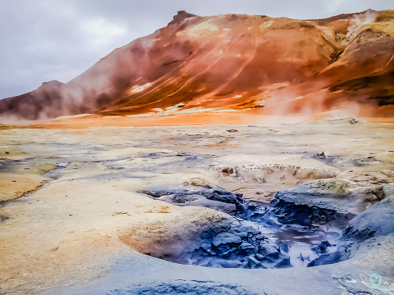
- The bubbling mud pools: observing the changing shapes on the surface – sometimes even a heart – is a fascinating experience that we never tire of contemplating.
- The impressive fissures that criss-cross the ochre soil are ideal for photography and for gauging the power of the subterranean forces at work.
- Colorful sulfur deposits, ranging from yellow to orange to red, add an almost unreal, mineral dimension to the landscape.

WHERE TO STAY IN myvatn
Fosshotel Myvatn, with beautiful lake views
See top-rated accommodations
Salt – Hotel Myvatn, near the pseudo-craters
See top-rated accommodations
Dimmuborgir Guesthouse, by the lake
See top-rated accommodations

How to get to Hverir: access and map
Where is Hverir in Iceland?
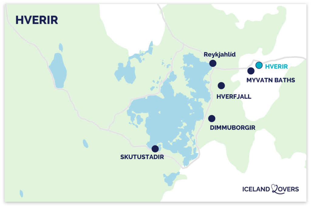
- Northern Iceland, around Lake Myvatn
- On Route 1, 6km east of Lake Myvatn (town of Reykjahlid), after the pass
- Driving time from Reykjahlid (main town on the lake): 10min
- Driving time from Akureyri: 1h25
- Driving time from Egilsstadir: 1h50
- Here is a map to help you find your way:
How to get there? Access road
The best way to reach Hverir is by car. We recommend renting a vehicle if you’re exploring northern Iceland: it allows you to visit all the sites in the Myvatn region at your own pace. No 4WD is required, as the access road is in excellent condition. Organized tours along Route 1 also stop here, making it a valid option if you’re traveling without a car. The site lies to the south of the road, easily visible from the carriageway.
Most group tours of Iceland stop at Dimmuborgir, and excursions to Lake Myvatn from Akureyri also go there. See options.

Parking
The Hverir parking lot is large and directly accessible from Route 1.
- paying
- payment is made via the Parka application.
- We advise you to park in the direction of your departure to facilitate manoeuvring on your return, especially if the parking lot is very full during the high summer season.
Sorry, we forgot to take a photo of the parking lot.
RENTING A CAR IN Iceland
Discover the best offers on Discovercars, our preferred platform!
On Route 1, no 4WD required, off Route 1, it depends on your plans.

Useful tips: duration, schedules, difficulties…
Best time to visit, opening hours and prices
The site is accessible at any time of day. Entry to the site is free; only the parking lot is chargeable.
In summer, the days in Iceland are very long, giving you great flexibility in planning your visit. There’s no single best time, strictly speaking, but coming in the early morning or late afternoon means more flattering low-angled light and fewer visitors.

Length of visit and main difficulties
The walking loop around the geothermal site can be completed in around half an hour. If you’re captivated by the mud pools and their ever-changing formations (which we were), you’re better off spending 1 hour on the site alone. If you add the hike to the Namafjall ridge, allow 1h30 in total.
The terrain is flat on the main part of the site, with no major difficulties. However, it is imperative to stay on the marked paths and not to approach unmarked active zones: the earth’s crust can be thin and the underground heat dangerous.
As a precaution, we advise against staying for more than an hour in the immediate vicinity of the mud ponds, due to the sulfur fumes.
Advice on how to visit

From the parking lot, start at the observation platform for a bird’s-eye view of the area and Namafjall mountain in the background. Then descend to the mud pools, and follow the loop past fumaroles and sulphur deposits. If you wish to hike the Namafjall, note that the left-hand side is steeper, with a slippery section: it’s best to go up the right-hand side and come back down the same way.
Visiting with children
Hverir is a site that fascinates children, but requires constant supervision. Active zones are marked by ropes and markers, which must not be crossed. Underground heat and sulfur fumes represent real risks. We recommend that you hold youngsters by the hand along the entire marked route, and explain the site’s safety rules in advance.
Catering, Toilets and Facilities
There are no facilities on the Hverir site: no restaurant, no toilets.
OUR GUIDE TO PLANNING A Dream trip
- 8 maps that make planning easier
- + 100 pre-selected locations
- Practical advice
- + 130 photos to help you choose

The observation platform: first contact with the geothermal zone
As soon as you leave the parking lot, the observation platform becomes the natural starting point for your visit. Impossible to miss with its protective barrier. It offers an overview of the entire geothermal zone: the various active structures stretch out before you, with the Namafjall mountain as a backdrop. We took the time to stop for a few minutes and identify the elements we wanted to explore more closely. Below the platform, large bubbling pools and hot springs are already visible. Warning: these are not swimming pools – the temperature is dangerous. Take advantage of this vantage point for your first panoramic shots of the site before descending into the area.

Bubbling mud pools
The mud pools are undoubtedly Hverir’s most fascinating feature. These acid hot springs form in high-temperature geothermal zones where water availability is limited. The process begins when a small quantity of water rises to the surface in an area rich in volcanic ash and clay. The acid and micro-organisms present then decompose the surrounding rock, producing the characteristic grey sludge.

We spent long minutes watching the bubbles rise to the surface, each one different from the last. Your imagination can run wild.
Boiling mud spurts regularly over the edges of the basins, building mini-volcano structures up to 1 to 1.5 m high. You can get up close and personal to the pools from a viewing platform. Keep to the marked areas: the earth’s crust around ponds is fragile and the mud hot.

Fumaroles and steam vents
Along the way, hissing fumaroles dot the geothermal zone. These natural vents emit gases and vapors directly from the underground hydrothermal system: mainly water vapor, but also sulfur dioxide, carbon dioxide and hydrogen sulfide. The latter is responsible for the characteristic rotten egg smell. You’ll receive it as soon as you arrive on site!

Although striking, the smell is temporary and poses no particular risk to the majority of visitors on a normal visit. Minerals are deposited around the vents over time, forming organically shaped chimneys. We found these structures particularly photogenic, especially against the light in low-angled areas.
UNFORGETTABLE ACTIVITIES IN Iceland
- Swimming in the Silfra fissure
- Horseback riding
- Hiking on a glacier
- Whale watching (from Reykjavik, Husavik or Akureyri)

Colored sulfur deposits
Sulphur deposits are one of Hverir’s most striking visual signatures. They are formed by the oxidation of hydrogen sulfide present in geothermal emissions: when this gas rises to the surface and cools, it solidifies into colored crystals. Pure sulfur is yellow, but depending on the associated elements, the deposits take on hues ranging from bright red through brown to orange.

These color variations contribute directly to the Martian look of the site. We were particularly struck by the contrast between these solid colors and the gray of the nearby mud ponds. It should be noted that sulfur deposits contribute to soil acidity, which explains the total absence of vegetation in this area.
Cracks: evidence of tectonic activity
Scattered throughout the site, cracks in the ground are one of Hverir’s most impressive features. They bear witness to the ongoing activity of this region of Iceland, crossed by the Mid-Atlantic Ridge that separates the Eurasian and North American plates.

Some of these cracks are deep, others more superficial – but all illustrate the ongoing geological dynamics of the subsoil. We found these formations particularly suitable for photography: placed in the foreground, they give a dimension and depth to the landscape that few other sites can match.
Hiking on the Namafjall
Beyond the main loop, Hverir offers the chance to climb Namafjall, the rhyolite mountain that dominates the site and rises 482m above sea level. A path leads from the geothermal zone, up the ridge and down the other side. Namafjall is part of the Krafla volcanic system, which also includes the Krafla volcano and the Stóra-Víti explosion crater, just north of Route 1. Allow around 1h30 in total to combine the site loop with this climb.

Other nearby attractions
If there’s anything noteworthy:
You can combine your visit to Hverir with these nearby attractions:
- Myvatn Nature Baths, natural geothermal baths in an exceptional setting (5-minute drive)
- The Hverfjall crater, a magnificent volcanic crater on whose rim you can walk (15min drive).
- Dimmuborgir, an impressive lava field with spectacular rock formations (15min drive)
- Skutustadir, with its pseudo-craters classified as part of Iceland’s natural heritage (25min drive)
VISIT Myvatn
- Attractions around Lake Myvatn
- Where to sleep: hotels and accommodation
- Itineraries: 1 day – 2 days
- How to get there
- Hverfjall
- Hverir
- Dimmuborgir
Frequently asked questions
Can you visit Hverir in winter?
The access road is cleared of snow, and the part closest to the parking lot is accessible in winter. See our article dedicated to visiting Hverir in winter.
Is Hverir accessible in summer without 4WD?
Yes, it is. Hverir lies directly on Route 1, the main road around Iceland.
Is the smell of sulfur in Hverir dangerous?
The smell of sulfur, comparable to that of rotten eggs, is present from the moment you enter the site. For the vast majority of visitors, a visit of normal duration poses no particular risk. However, it is advisable not to park for more than an hour in the direct vicinity of the sludge ponds. People with severe respiratory problems should take precautions.
Does Hverir go by any other names?
Yes. The site is sometimes referred to as Hverarönd or Namaskard. The latter corresponds to the geographic pass on which it is located. Namafjall is the name of the rhyolite mountain that dominates the whole area. These different names can be confusing when searching, but they all refer to the same geothermal zone on the shores of Lake Myvatn.
PLAN YOUR SUMMER TRIP TO iceland
- Best of
What to do in Iceland
The most beautiful waterfalls
The most beautiful black sand beaches
Volcanic craters to climb
Lava caves to visit
Best excursions from Reykjavik

- Practical advice
Summer travel tips
How to rent a car in Iceland
Driving tips
Where to stay in Iceland
Itineraries: 3 days – 4 days – 5 days – 1 week – 10 days

- The must-dos
What to do in Reykjavik
Best attractions in the Golden Circle
South Coast attractions
Snaefellsnes Peninsula
Silver Circle
Lake Myvatn attractions