
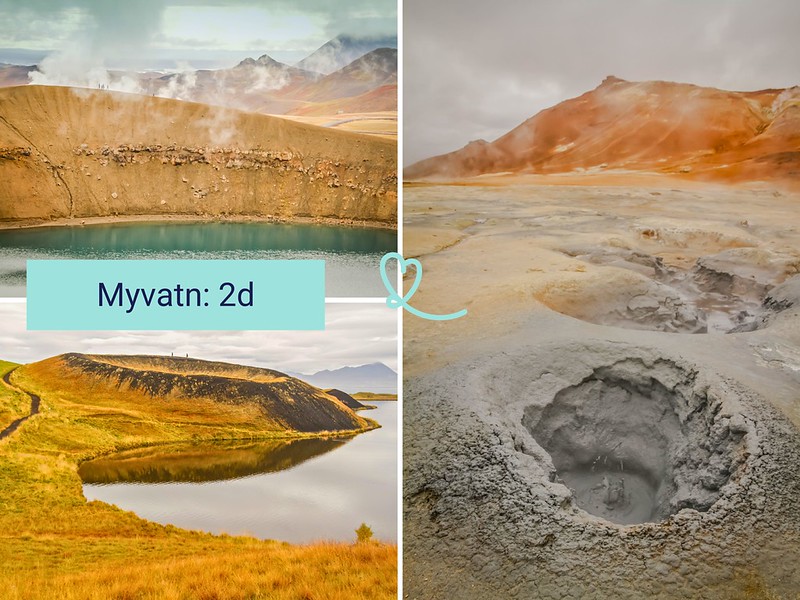
Planning to visit Lake Myvatn in 2 days on a road trip around Iceland? It’s the ideal length of time to explore this volcanic region in the north-east of the country, concentrated in landscapes of rare diversity: steaming geothermal zones, lava fields, craters and shallow lakes.
With our itinerary, we’ll guide you through Myvatn to make the most of your stay!
This opinion is completely independent, based on our experiences. We visited the region anonymously, making our own choices and paying our bills in full.
Content
Practical tips for visiting Lake Myvatn in 2 days
What can you see on Lake Myvatn in 2 days? Is it long enough?
Two days are enough to cover the must-see sites around the lake: geothermal zones, Krafla lava fields, craters, lake tour and natural baths. The perimeter is compact, distances short. A balanced rhythm is perfectly possible.
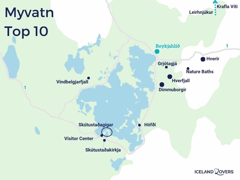
Map of must-see attractions
To help you find your way around our itinerary below, here’s our map of Lake Myvatn’s main tourist attractions:
Getting around Lake Mývatn
A car is essential for exploring the region: the sites are scattered over some 36km around the lake, and no public transport links the natural sites together. In summer, public buses (Strætó) run between Akureyri and Reykjahlíð, the main village, but they don’t serve isolated sites.
Distances are short, roads paved and well-maintained in summer.
RENTING A CAR IN Iceland
Discover the best offers on Discovercars, our preferred platform!
On Route 1, no 4WD required, off Route 1, it depends on your plans.

Our ideal itinerary: 2 days at Lake Mývatn
This itinerary is designed for travelers arriving from Egilsstaðir (east) and departing towards Akureyri (west), in the classic Icelandic road trip direction.
The reverse order works just as well.
As the sites are so close together, we’ve organized the days according to physical effort rather than strict geography: an uphill climb on the first day, with recovery at the baths in the late afternoon, and the most demanding hike reserved for the rested morning of the second day.
To plan your own itinerary, find our selection of the best attractions in Myvatn.
Day 1 – From Egilsstadir: possible detour to Dettifoss
The drive from Egilsstaðir to the lake takes around 1h45. If you leave early, a detour to the Dettifoss and Selfoss waterfalls is a must: they’re about a 45-minute drive from Mývatn, and this detour allows you to see Europe’s most powerful waterfall before heading back to the lake. We felt the vibrations of the ground several metres from the edge of Dettifoss.

A little further upstream, Selfoss offers an equally remarkable setting. Allow 1h30 to 2h on site, depending on your pace.
Day 1 – Stop 1: Hverir / Námafjall
First stop along Route 1, about 6km east of Reykjahlíd: the Hverir geothermal zone, also known as Námafjall. The visual shock is immediate. The terrain, totally devoid of vegetation, is covered with pools of bubbling mud, fumaroles and solfataras of ochre, yellow and grey hues. We discovered a landscape that resembled a different planet, with the ever-present smell of sulfur reminding us that the earth is alive just a few meters beneath your feet.

Take the time to observe each formation: each pond has its own characteristics. You can also climb the slopes of Námafjall hill for a panoramic view of the whole area and the lake in the background. Allow 30min to 1h. Pay parking is available. Keep to the marked trails, as the ground can be very hot in the vicinity of fumaroles.
Day 1 – Stop 2: Grjótagjá
A few minutes’ drive away, the Grjótagjá cave is a geological interlude of a different kind. This small lava cavity is home to a limpid blue hot spring, illuminated by light filtering through cracks in the rock. We were captivated by the beauty of this natural pool, whose hue varies according to the time of day and the light. The descent into the cave is very short but difficult.

Swimming has been banned since the Krafla eruptions of 1970-1980, which raised the water temperature to dangerous levels. The site was also made famous by its appearance in the Game of Thrones series. Allow 15-30 minutes; access is via a small dirt road on Route 860. Free of charge. Private land: the road may be closed at any time.
Day 1 – Stop 3: Dimmuborgir
Dimmuborgir, whose name means “dark castles”, is a natural labyrinth of amazingly shaped lava formations, located around 3km south of Reykjahlíd on route 848. These columns, arches and cavities of volcanic rock were formed around 2,300 years ago, when a lake of lava solidified around columns of steam. We wandered through this maze whose silhouettes are reminiscent of the ruins of an ancient fortress – in places, it’s understandable that Icelandic folklore has associated trolls and hidden creatures with it.

Several signposted trails of varying difficulty allow you to explore the site, some of which cross remarkable natural arches such as Kirkjan, “the church”. We suggest you arrive in the late afternoon: the buses stop here during the day, and coming later guarantees greater peace and quiet. Duration: 1h to 2h depending on the circuit. Paying toilets on site; a small café is open in summer.
OUR GUIDE TO PLANNING A Dream trip
- 8 maps that make planning easier
- + 100 pre-selected locations
- Practical advice
- + 130 photos to help you choose
Day 1 – Stop 4: Höfði and Kalfaströnd
After the mineral worlds of the morning, the Höfði peninsula offers a welcome transition. This birch-wooded promontory on the eastern shore of the lake is one of the few places in the region where vegetation takes over from rock. Its shaded paths run along the shore, offering open views of the pseudocraters on the opposite bank and the surrounding mountains.

At Kalfaströnd, lava pillars emerge directly from the water – “klasar”, formed by the interaction between molten lava and the lake. These winding columns create a landscape we’ve seen nowhere else. Allow 30min to 1h. The trails are relatively flat in Höfði. Free parking, pay toilets.
Day 1 – Stop 5: Earth Lagoon (Myvatn Nature Baths)
To round off this first day, there’s nothing like an hour in the geothermal pools of Earth Lagoon, formerly known as Myvatn Nature Baths. Located around 3km east of Reykjahlíð on Route 1, these baths with water naturally heated to 36-40°C are ideal for recuperating after a day’s walking. The mineral-rich water comes from underground springs more than 2,500m below the surface.

We particularly appreciated the peacefulness of the area, which is much more intimate than the Blue Lagoon in the south. The complex features a large outdoor pool, natural steam baths and a relaxation area, as well as an on-site café-restaurant. Check out the latest news on the official website here.
Book your ticket now to save time!
Overnight at Lake Myvatn: where to sleep
WHERE TO STAY IN myvatn
Fosshotel Myvatn, with beautiful lake views
See top-rated accommodations
Salt – Hotel Myvatn, near the pseudo-craters
See top-rated accommodations
Dimmuborgir Guesthouse, by the lake
See top-rated accommodations

Day 2 – Stop 1: Hike to Hverfjall crater
Start the second day with the most demanding physical effort, when your legs are still fresh. The Hverfjall crater, also spelled Hverfell, is one of the largest explosion craters in the world: almost 1km in diameter, 420m high, formed around 2500 years ago during a phreatomagmatic eruption. The climb is over loose ash and black gravel, steep and unshaded.

Once at the top, the reward is worthy of the effort: a 360° panorama of Lake Mývatn, the Dimmuborgir lava fields and the Krafla mountains. You can walk along the rim of the crater on a circular trail that goes all the way around. We found the view absolutely breathtaking, especially in fine weather. Allow 1 to 2 hours. Hiking boots essential. Do not climb in strong winds. Pay parking.
Day 2 – Stop 2: Leirhnjúkur
The following two sites are located in the same area, about 15km northeast of Reykjahlíð via Route 863, and can naturally be visited together.
Start at Leirhnjúkur, in the heart of the Krafla volcanic system. This was the most memorable walk in the whole region. The still-smoldering lava fields, remnants of the “Krafla fires” that erupted between 1975 and 1984, give off a unique end-of-the-world impression.

We were there early, and the feeling of being alone in the world after a catastrophe was striking. Follow the signposted trail that winds between the various geothermal zones. Allow 1 to 2 hours for the complete loop.

It’s time to book!
Compare everything: companies, prices, schedules and availability.
Day 2 – Stop 3: Víti crater (Krafla area)
The Víti crater is just a few minutes away, accessible from the Krafla geothermal power station parking lot. Its name means “hell” in Icelandic, and the contrast is striking: at the bottom of a dark-walled crater formed in 1724, a lake of turquoise water of surprising intensity.

We were surprised by the color, which varies according to the light and the season. A path runs along the edge of the crater, taking you all the way around. Allow 20 to 45 minutes. Pay parking; no on-site catering.
Day 2 – Stop 4: Skútustadagígar pseudocraters
Before leaving Myvatn, make one last stop on the southern shore of the lake, at the Skútustadagígar pseudocraters. Our favorite!
These small grass-covered knolls, scattered along the water’s edge, are one of the region’s most original sites. Unlike traditional craters, these formations were not created by volcanic eruptions, but by the explosion of steam caused by lava flowing over marshy ground.

We walked along these pseudocraters on the circular path, and the contrast between their greenery and the mineral landscapes of the previous day was striking. The loop is short (30min to 1h), relatively flat and well maintained. Free of charge. Free parking next to the Skútustadakirkja church, which you can also see as you pass by.
Day 2 – Departure for Akureyri: stop at Godafoss
The drive to Akureyri from Myvatn takes about 1 hour. On the way, a stop at the Goðafoss waterfall is a must: it’s directly off Route 1, and parking is just a few seconds away. Approximately 30m wide, this waterfall flows in a semicircle into an open setting.

Its name “cascade of the gods” comes from a seminal episode in Icelandic history: in the year 1000, the chief is said to have thrown his idols here after Iceland’s conversion to Christianity. Allow around 30min to walk around it and enjoy both shores. It’s an easy and visually rewarding stop to conclude this stay in Myvatn.
Alternative 1: If you have more time
If you have an extra half-day, there are a number of sites well worth a visit.
- Vindbelgjarfjall is a mountain on the western shore of the lake (529m above sea level). The round-trip hike takes 2 to 3 hours and offers the most complete panorama of the entire lake.
- The Mývatn Gigur Visitor Center, near Skútustaðir, is also a good geological introduction to the region if you’re not yet familiar with volcanic terminology.
- Finally, birdwatching around the lake is an activity in its own right: Mývatn is home to Europe’s greatest diversity of nesting ducks. The Sigurgeir Bird Museum, on the north-eastern shore, boasts a comprehensive collection of naturalized species. Visit the official website for more info here.

Alternatives 2: Sports and outdoor activities
For lovers of the great outdoors, the region offers other ways to explore the countryside. ATV/buggy excursions allow you to explore the lava fields off the beaten track. See available ATV options.
Horseback riding is also available in the region, to discover the countryside at a different pace. In autumn and spring (September to April), the lake is also one of Iceland’s best spots for viewing the northern lights, thanks to its low light pollution and northerly position.

VISIT Myvatn
- Attractions around Lake Myvatn
- Where to sleep: hotels and accommodation
- Itineraries: 1 day – 2 days
- How to get there
- Hverfjall
- Hverir
- Dimmuborgir
What you need to know for your stay at Lake Mývatn
The weather at Lake Mývatn
Iceland’s weather is notoriously changeable, and the Mývatn region is no exception. In summer (June-August), temperatures generally fluctuate between 8°C and 15°C, with long days (sleepless nights in June-July) allowing you to visit at any time of day. In autumn and spring, temperatures drop and the wind can be strong, especially on the Hverfjall ridge. In winter, some access roads are closed, including those to Krafla (route 863). Whatever the season, a raincoat and warm clothing are essential. Come rain or fog, Hverir and Dimmuborgir are still open to visitors.
The crowds at Lake Mývatn
The high season (July-August) attracts many visitors (same simoins as the south coast), especially to the most accessible sites such as Hverir and Dimmuborgir. The midday hours are the busiest. We recommend an early start, as early as 8am, to take in the highlights before the crowds. In Dimmuborgir in particular, going beyond the paths closest to the parking lot radically changes the experience.
Adapt your itinerary when it rains
Rain doesn’t compromise your visit to Mývatn: most of the sites are open-air and just as interesting on a cloudy day, sometimes even more so (the Hverir fumaroles are more spectacular in the mist). On the other hand, the ascent to Hverfjall is not recommended in strong winds or heavy rain, as the ash floor becomes slippery.
PLAN YOUR SUMMER TRIP TO iceland
- Best of
What to do in Iceland
The most beautiful waterfalls
The most beautiful black sand beaches
Volcanic craters to climb
Lava caves to visit
Best excursions from Reykjavik

- Practical advice
Summer travel tips
How to rent a car in Iceland
Driving tips
Where to stay in Iceland
Itineraries: 3 days – 4 days – 5 days – 1 week – 10 days

- The must-dos
What to do in Reykjavik
Best attractions in the Golden Circle
South Coast attractions
Snaefellsnes Peninsula
Silver Circle
Lake Myvatn attractions