
In northern Iceland, the geothermal area of Leirhnjukur offers one of the most striking experiences the island has to offer: walking through a lava field that is still smoking, more than 40 years after the last eruption. We were struck by the raw power of this landscape, where the earth still seems to be building beneath your feet. It’s a place like no other.
In this article, you’ll find our photos and tips for making the most of your visit to Leirhnjukur.

This opinion is completely independent, based on our experiences. We visited the region anonymously, making our own choices and paying our bills in full.
Content
Why visit Leirhnjukur
Is Leirhnjukur worth a visit? Our opinion:
Yes, Leirhnjukur is definitely worth a visit. It’s one of the few places in the world where you can see steaming lava in the open air, with no barrier between the visitor and the geothermal activity. The long hiking loop through the lava field is an extraordinary experience: wisps of smoke rise from the dark ground, the colors of the rhyolite contrast with the black of the solidified lava, and the silence is broken only by the hiss of steam. We hadn’t seen anything like it, even after visiting Hverir and the Viti crater.
This is one of the best attractions in the Lake Myvatn region.

Our favorite moments
The Leirhnjukur hike offered us several highlights, difficult to rank in order of preference:
- Lava still smoldering: walking through the lava field where fumaroles are still escaping, 40 years after the last eruption, is an unforgettable image.
- Colorful geothermal pools: the rhyolite hillside pools display fascinating hues, from milky blue to orange-red, depending on bacteria and temperature.
- Color contrasts: the green of moss on light-colored rock, the black of lava, the ochre of rhyolite…

WHERE TO STAY IN myvatn
Fosshotel Myvatn, with beautiful lake views
See top-rated accommodations
Salt – Hotel Myvatn, near the pseudo-craters
See top-rated accommodations
Dimmuborgir Guesthouse, by the lake
See top-rated accommodations

How to get to Leirhnjukur: access and map
Where is Leirhnjukur?
- North Iceland, in the Krafla caldera
- Near Lake Myvatn
- Driving time from Reykjahlid (Lake Myvatn): 20min
- Driving time from Akureyri: 1h30
- Here is a map to help you find your way. Leirhnjukur is to the north of this map.
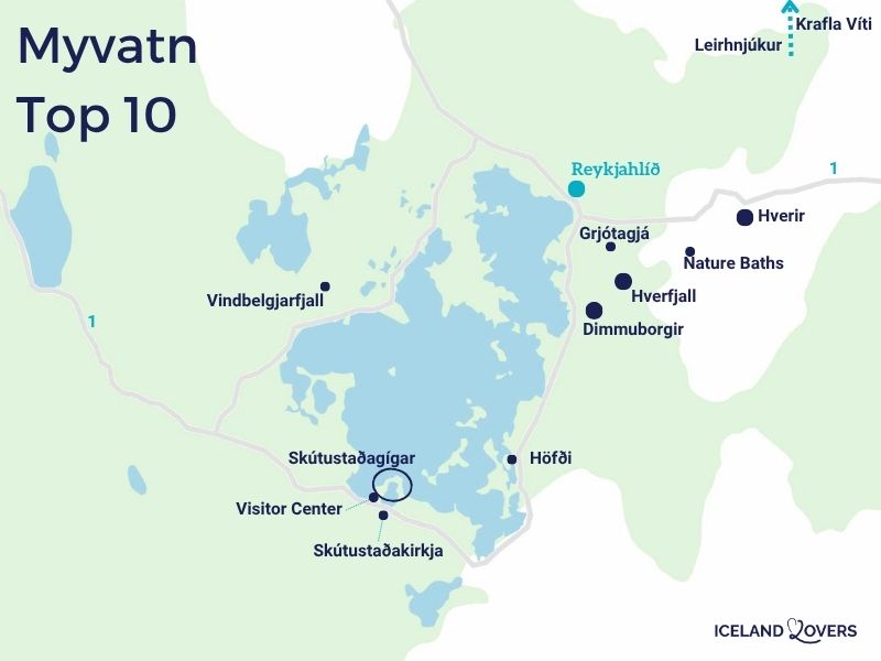
How to get there? Access road
A car is essential to reach Leirhnjukur: there is no public transport to the site, and organized tours that include it are rare. From Myvatn, take Route 1 east for about 6km, then turn left towards Viti and Krafla, onto Route 863. It begins almost opposite the Hverir geothermal zone.
Parking
The Leirhnjukur parking lot is on the left. There are several other parking lots along the way: take care not to confuse them. It is not free.
Sorry, we forgot to take a photo of the parking lot.
RENTING A CAR IN Iceland
Discover the best offers on Discovercars, our preferred platform!
On Route 1, no 4WD required, off Route 1, it depends on your plans.

Useful tips: duration, schedules, difficulties…
Best time to visit, opening hours and prices
Leirhnjukur is freely accessible, with no fixed opening hours. In summer, Icelandic light works in your favor: the long hours of daylight mean you can visit at any time of day. The site is open to walkers of all abilities. The only thing you need to do before setting off is check that there are no thunderstorms in the area, as geothermal zones can react to changes in the weather.

Length of visit and main difficulties
Two loops start from the same parking lot, but with very different durations. The short loop, which leads to the geothermal sights on the hillside, takes about 1 hour. The big loop, through the steaming lava field, takes at least 2 hours if you take the time to observe!
The walk is generally easy, with no long slopes or major technical difficulties. It should be noted, however, that the wooden planks of the small loop can be slippery in wet weather. On the long loop, small posts line the route to guide visitors away from areas where underground heat remains high enough to damage footwear. Never leave the marked trails!

Advice on how to visit
Nothing in particular. And don’t forget to turn around regularly: the views of the black rocks and caldera relief are just as beautiful from the inside of the trail as from the open vantage points.
Visiting with children
The site is accessible to families in good physical condition. Curious children will love the colors of the pools and the smoke rising from the floor. However, youngsters need to be kept on their toes: marked paths must be strictly followed, as some areas on the surface of the lava remain dangerously hot. Wet wood boards also require special attention to prevent falls.

Catering, Toilets and Facilities
Toilets are available in the parking lot, but are not always open. Apart from this, the site has no catering or boutique facilities.
OUR GUIDE TO PLANNING A Dream trip
- 8 maps that make planning easier
- + 100 pre-selected locations
- Practical advice
- + 130 photos to help you choose
The Krafla caldera: geological context

To understand Leirhnjukur, you first need to grasp the scale of the Krafla caldera that surrounds it. This volcanic depression is 10km long and 2km deep. It is the result of millennia of eruptive activity, punctuated by two particularly intense periods: the Myvatn fires, between 1724 and 1729, and the Krafla fires, between 1975 and 1984.

We walked through an area shaped by these two cycles, giving a striking perspective on the geological time scale. The lava flows resulting from these eruptions now cover vast areas around the site, and their still recent appearance, e.g. cracked, layered surfaces, testifies to the speed with which the lava invaded the landscape. You hear this story with every step along the trail.
The rhyolite hill geothermal basins
The hill that gives the site its name is a formation of rhyolite, a clear volcanic rock, which rises to an altitude of 593 meters, less than 50 meters above the surrounding lava field. Its appearance contrasts sharply with the dominant black of the landscape.

On its slopes, a boardwalk leads to the geothermal pools, the main attraction of the little loop. These natural pools with their changing hues (milky blue, pale green, ochre, red) owe their colors to the thermophilic bacteria that thrive in them, as well as to temperature variations.
The boardwalk goes three-quarters of the way around them, allowing you to observe them from different angles. On cloudy days, the hues change with the passing sun: sometimes pink and grey, sometimes orange and brown. You’ll rarely see such vivid colors in a natural setting.

Crossing the steaming lava field
This is the heart of the visit, and by far the most striking part of the Leirhnjukur hike. The long loop quickly leaves the boardwalk and enters the lava field created by the Krafla eruptions. From the very first meters, the scenery changes: the black, flaky surface of the lava occupies the entire field of vision, punctuated by dozens of fumaroles.

We had the sensation of walking on another planet, an impression that the photos fail to convey. Marker posts replace the wooden path here: they indicate areas where the surface lava has cooled sufficiently to be walked on without risk to footwear. The last eruptive episode dates back to 1984, but the underground heat is still very much present: never stray far from the route.
Observe the few places where nature is starting to grow: moss!


It’s time to book!
Compare everything: companies, prices, schedules and availability.
Rock formations and geological curiosities
Beyond the lava and the pools, the Leirhnjukur trail has many geological details that deserve attention. The small loop crosses part of the rhyolite hill, where curiosities of all shades appear: white, red, black, with carpets of green moss that seem incongruous in this mineral landscape.

We also noticed numerous cracks in the rock, some of them gaping, testifying to the permanent movement of tectonic plates in Iceland. The country is crossed by the Mid-Atlantic Ridge, and Krafla is one of its most active expressions. The very shape of solidified lava can be fascinating: folded surfaces, trapped bubbles, stretched filaments. Take the time to look at your feet, not just the horizon.

If you look back as you hike, you’ll see the Viti crater and Krafla lake in the background, providing a good reference point for your progress through the caldera.

Disconcerting landscapes
One of the most lasting effects of a visit to Leirhnjukur is the difficulty of believing that you are actually on Earth. From the first 100 meters from the parking lot, the landscape takes on a post-apocalyptic dimension: the colors are too vivid, the textures too strange, the underground activity too visible to appear ordinary. This impression intensifies along the way, particularly in areas where the smoke is densest.

Other nearby attractions
If there’s anything noteworthy:
You can combine your visit to Leirhnjukur with these nearby attractions:
- Viti crater, located in the same Krafla caldera: an explosion crater filled with a turquoise-tinted lake, accessible from the same area (a few minutes’ drive from the Leirhnjukur parking lot).
- Hverir (also known as Namaskard), the geothermal zone with bubbling mud pots and sulfurous fumaroles, off Route 1, about a 10-minute drive.
- Hverfjall craterThe Hverfjall crater, an almost perfectly circular tephra crater overlooking Lake Myvatn, is about a 20-minute drive away.
- DimmuborgirDimmuborgir, the lava field with its basalt formations sculpted by the elements, often nicknamed the “city of trolls”, is about a 20-minute drive away.
Frequently asked questions
Is the Leirhnjukur hike accessible to all?
The walk is considered easy, with no major changes in altitude or technical difficulties. It is suitable for walkers of all levels in good physical condition. The volcanic terrain, on the other hand, requires closed, stable footwear. Wooden planks can be slippery and the lava surface uneven. The site is not accessible to people with reduced mobility.
Can we visit Leirhnjukur in winter?
No. The site is less accessible in winter. Snow can cover the marker posts that guide hikers on the long loop, making it difficult – even dangerous – to find one’s way around the lava field.
PLAN YOUR SUMMER TRIP TO iceland
- Best of
What to do in Iceland
The most beautiful waterfalls
The most beautiful black sand beaches
Volcanic craters to climb
Lava caves to visit
Best excursions from Reykjavik

- Practical advice
Summer travel tips
How to rent a car in Iceland
Driving tips
Where to stay in Iceland
Itineraries: 3 days – 4 days – 5 days – 1 week – 10 days

- The must-dos
What to do in Reykjavik
Best attractions in the Golden Circle
South Coast attractions
Snaefellsnes Peninsula
Silver Circle
Lake Myvatn attractions

