
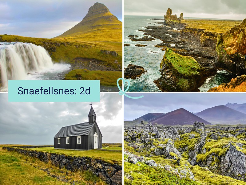
Planning a 2-day visit to the Snaefellsnes peninsula? It’s the ideal length of time to discover this region often nicknamed “Iceland in miniature”. In just a few dozen kilometers, it boasts a striking diversity of landscapes: fjords, lava fields, waterfalls, cliffs, glaciers and fishing villages.
Here is our ideal itinerary for visiting Snaefellsnes in 2 days!
This opinion is completely independent, based on our experiences. We visited the region anonymously, making our own choices and paying our bills in full.
Content
Practical tips for visiting Snaefellsnes in 2 days
What can you see in Snaefellsnes in 2 days? Is it long enough?
Two days is an ideal length of time to explore the Snaefellsnes peninsula. This allows you to discover the peninsula’s must-see sites and get off the beaten track. You don’t need a 4WD, but you can go anywhere.
If you have the opportunity to spend 2 days there instead of just one, we highly recommend it!
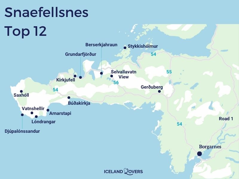
Map of must-see attractions
To help you find your way around our itinerary below, here’s our map of the main tourist attractions in Snaefellsnes:
Getting around the Snaefellsnes peninsula
A car is essential for exploring Snaefellsnes. Route 54 circles the peninsula and remains well maintained. A conventional vehicle (2WD) is sufficient for most sites. Only mountain roads (570, F575) require 4WD. We highly recommend renting a vehicle to enjoy the freedom to stop whenever the scenery inspires you. The distances between attractions are short, making driving a pleasure.
Car option: See all our tips for renting a car in Iceland.
Guided options: If you don’t want to drive, there are excursions departing from Reykjavik for 2 days, but these are combined with the Silver Circle or the Golden Circle, so there’s only one day in Snaefellsnes. See options.

Where to sleep in Snaefellsnes
For this 2-day itinerary, we suggest you spend the night in Grundarfjörður. This small fishing port lies at the foot of Kirkjufell, Iceland’s most photographed mountain. Enjoy sunrises and sunsets over this iconic silhouette. The village has all the services you need: supermarket, petrol station, campsite and a wide range of accommodation. See our article on the best places to stay in Snaefellsnes.
See directly the best rated accommodations in Grundarfjordur.

Our ideal itinerary: 2 days in Snaefellsnes
Here’s our suggested itinerary for visiting Snaefellsnes in 2 days, with an overnight stay in Grundarfjörður.
We’ll tell you what you need in a 4WD car.
You arrive via Route 1 and then Route 54. Go as far as Route 56.
RENTING A CAR IN Iceland
Discover the best offers on Discovercars, our preferred platform!
On Route 1, no 4WD required, off Route 1, it depends on your plans.

Day 1 – Stop 1: Selvallavatn viewpoint and Selvallafoss
Start your first day with a stop along Route 56, which runs through the center of the peninsula. The panoramic view of Lake Selvallavatn and the surrounding colorful hills is an excellent introduction to the geological diversity of Snaefellsnes.
In addition to the lake, you can observe the lava field and surrounding volcanoes. We really enjoyed the different hues of the landscape, from the green of the moss to the ochre hues of the hills. Not far from the parking lot, a small waterfall called Selvallafoss is well worth a visit.
If you’d like to stretch your legs, two short hikes leave from the parking lot: one to the lake and the other to Horn Hill, which offers an even wider panorama.
Allow 10 to 40min depending on how much you want to explore.

Day 1 – Stop 2: Berserkjahraun lava field
Continue to the north of the peninsula along route 558, known as Berserkjahraunsvegur. This unpaved tertiary road crosses one of Iceland’s most beautiful lava fields. The tormented shapes of the rock, softened by a carpet of intense green moss, create a landscape that seems frozen in time.
The route passes between two small fjords, Hraunsfjördur and Seljafjördur, adding beautiful views of the water and surrounding mountains. We discovered this place on the advice of a local and we thank him again!

The road is passable by conventional car (2WD) in summer, generally from June to October. But we still recommend a small 4WD to take it.
Warning: never step on moss, as it takes decades to regenerate.
Allow 1 to 2 hours depending on the number of stops and photographs…

Day 1 – Alternative Stop 2: Stykkishólmur and the Viking Sushi Cruise
If you prefer to add a little sailing to your stay, spend half a day in Stykkishólmur, the largest town on the peninsula. Its colorful little port is well worth a stroll, and the village’s modern church is surprisingly pure in its architecture.

From Stykkishólmur, you can embark on a cruise through the islands of Breiðafjörður. The outing lasts 2 to 3 hours and takes you to a series of surprisingly shaped islets lined with basalt columns. On the way back, enjoy a tasting of “Viking Sushi”, freshly caught seafood. We found this experience very different from the rest of the overland itinerary. Book your cruise.
For unusual views of Kirkjufell from the sea, we also recommend a kayak tour departing from Grundarfjörður: See availability and book.

OUR GUIDES TO PLAN YOUR Dream trip
Day 1 – Stop 3: Viewpoint over Kirkjufell
You’ve now reached the north coast. Stop short of the town of Grundarfjordur to admire the iconic mountain of Kirkjufell.
Take a look at its slender 463m-high form and its strata. Its conical silhouette rises from the water’s edge
Allow 10 minutes.

Day 1 – Stop 4: Grundarfoss waterfall
Head back towards Grundarfjörður to discover Grundarfoss waterfall, just a few minutes from the village. The waterfall is already visible from the road and parking lot, giving a foretaste of the show. It takes about 15 minutes to walk to the foot of the waterfall.
The more motivated can climb to the top (right-hand side), with an additional 30min round trip. We found the setting very pleasant on a clear day. Please note: do not feed the Icelandic horses you meet along the trail. Depart from the edge of Route 54, free parking.

Day 1 – Stop 6: Svödufoss waterfall
Start your second day by heading west towards Ólafsvík. The Svöðufoss waterfall, still little visited, can be reached after a short 7-minute walk from the parking lot. The paved path leads directly to the foot of the waterfall.
The more motivated can climb above for an additional viewpoint (allow an extra 30min round trip). We liked the calm of this place, away from the crowds of the main sites. Access is via a short stretch of gravel road, passable by classic car in summer.
Allow 20min to 1h depending on your desire to explore.

Day 1 – Stop 6: Kirkjufellsfoss at sunset
End your first day at the peninsula’s most emblematic site. Kirkjufell is Iceland’s most photographed mountain. Its conical silhouette, 463m high, stands on the water’s edge to the west of Grundarfjörður. In the foreground, twin waterfalls, the Kirkjufellsfoss, complete a panorama that has become iconic.
We were struck by the beauty of the place at the end of the day, when the low-angled light sculpts the mountain relief. If you get there after 5pm, you’ll avoid the busloads of visitors that are concentrated between 10am and 3pm. Footpaths run alongside the waterfalls on both sides. It’s also possible to walk around the mountain, a seldom-visited loop. Camera-controlled pay parking.
Allow 30min to 1h.

Day 2 – Stop 1: Saxhóll Crater
Continue to the western end of the peninsula to climb the Saxhóll crater. This red volcanic cone, partly covered in moss, can be reached via a metal staircase that takes just a few minutes to reach the top. From up there, you’ll discover the interior of the crater and an exceptional view of the tip of the peninsula and the Snaefellsjökull glacier. We found the climb easy and the panorama rewarding. Warning: in very strong winds, the staircase can become dangerous. Parking at the foot of the crater. No on-site sanitary facilities.
Allow 30-45 minutes to enjoy the panorama.

Day 2 – Stop 2: Djúpalónssandur beach
Head back down the coast to Djúpalónssandur, one of the peninsula’s most beautiful black sand beaches. The site features dark, ocean-polished pebbles, coves framed by lava formations and the remains of a former British trawler. The nearby cove of Dritvík completes the visit. The whole area is part of the Snaefellsjökull National Park, with marked trails. We recommend caution in the face of sneaky waves: don’t get too close to the water’s edge.
Allow 20 to 40min.

Day 2 – Stop 3: Malariff lighthouse
On the other side of the Lóndrangar promontory is a lighthouse with a small museum. It provides information on the geology, flora and fauna of the coastal zone. It’s an instructive complement to a visit to the cliffs, and an opportunity to learn more about the natural history of this tip of the peninsula.
We found the museum interesting for understanding the formation of the landscapes we had observed throughout the morning. From Grundarfjörður, it’s about a 50-minute drive.
Allow 15-30 minutes for the lighthouse and museum.

Day 2 – Stop 4: Lóndrangar cliffs
A short drive away, the Lóndrangar cliffs are among the peninsula’s most beautiful sites. These two basalt pillars are the remains of an ancient crater eroded by the ocean. They stand up to the crashing waves that crash against them, while seabirds nest in the walls.
The surrounding lava field is covered in moss. We loved lingering here on a clear day to observe the ballet between sea and rock. Ample parking and well-maintained footpath.
Allow 15-30min.

Day 2 – Stop 5 Arnarstapi
Continue on to the coastal village of Arnarstapi, nestled at the foot of the Snaefellsjökull glacier. Its main attraction lies in the walk along the cliffs, which reveals spectacular lava formations: the natural arch of Gatklettur, rock bridges and columns sculpted by erosion. The trail follows the coastline for about 15 minutes one way. For us, who appreciate rock formations, it was a real treat, especially with the view of the mountains in the background when the sky is clear. The path is well-maintained and accessible to people with reduced mobility.
Allow around 1 hour for the whole walk.
There are restaurants, cafés and a petrol station on site.

Day 2 – Stop 6: Raudfeldsgja Canyon
Head east again for a stop at the Rauðfeldsgjá canyon, a narrow gorge carved out of the mountains on the south coast of Snaefellsnes. It’s possible to venture out on foot, making your way between the rock faces squeezed above a small stream. The deeper you go into the gorge, the tighter the passage becomes, and the terrain becomes slippery: some sections require you to climb over wet rocks.
At the far end, a small waterfall marks the point where progress becomes difficult. We recommend hiking boots, as the stones are very slippery. The site is very busy in high season, so it’s best to visit in the early afternoon to avoid long waits.
Allow 30min to 1h depending on your progress.


It’s time to book!
Compare everything: companies, prices, schedules and availability.
Day 2 – Stop 7: Budakirkja, the black church
Last stop on your itinerary: Búðakirkja, a small all-black church, isolated in the middle of a lava field on the south coast. Its dark silhouette contrasts intensely with the green of the moss in summer. The church is closed to the public except for local ceremonies and weddings: you can only admire it from the outside. Access 5 minutes from Route 54.
Quick stop: 5 to 15min are enough.

Day 2 – Stop 8: Gerðuberg basalt columns
Head back east for a detour to Gerðuberg, a natural wall of hexagonal basalt columns visible from Route 54. These regular formations, several metres high, seem to form a natural rampart for the crater behind (Ytri-Rauðarmelskúla). The site is quick to discover and an easy stop to integrate. We found the place interesting for its natural geometry, even if the visit remains brief. The road can be bumpy: drive slowly.
Allow 15-20 minutes on site.

Day 2 – Stop 9: Ytri-Tunga beach and seal watching
Head up the south coast to Ytri-Tunga, one of Iceland’s best places to see seals in their natural habitat. Seals regularly bask on the beach rocks, on sunny or overcast days. We advise you to bring binoculars, as the rocks close to the water are slippery and it’s best to keep a distance of at least 50m. The site also offers beautiful views of the peninsula’s mountains. Parking in the immediate vicinity of the observation area.
Allow 15min to 1h depending on the number of seals present.

WHERE TO STAY IN Iceland
Our independent picks for the accommodation of your dreams:

Alternative 1: Snaefellsjökull glacier
If you’re a hiker in good physical condition, you can replace one of the Day 2 stages with a guided ascent of the Snaefellsjökull glacier. This glacier-volcano, the peninsula’s highest point at 1,446m, inspired Jules Verne to write his novel Journey to the Center of the Earth. The tour lasts around 7 hours round trip and takes place mainly on the glacier, which offers a 360° view of Snaefellsnes and the ocean. A guide is compulsory because of the crevasses. No previous glacier experience is required, but glacier equipment is provided. Not recommended for children under 16. Reserve your place (groups fill up fast).
For a less physical alternative, ATV ATV tours and groomer allow you to approach the glacier without hiking (3h, January to September, departure from Arnarstapi).

Alternative 2: with Vatnshellir cave
If you’d like to add an underground experience to your itinerary, Vatnshellir Cave can easily be combined with the Day 2 tours. This underground lava tube is located not far from Lóndrangar. The guided tour takes you 35m underground, via a spiral staircase, into a world of frozen volcanic rock.
We found the experience of going down deep unique, even if this cave isn’t the most spectacular we’ve seen in Iceland(see our list). Indoor temperatures are around 0 to 4°C all year round: bring warm layers and sturdy footwear. Caution: the spiral staircase can pose a problem for people prone to vertigo or knee pain.
Allow 1 hour. Book your visit.

Alternative 3: with 4WD: route 570 to the glacier
Lovers of scenic drives and relaxation can add two more stages to their program. Route 570, known as Jökulshálsvegur, is a mountain road that leads to the highest point accessible by car on the peninsula, just below the summit of Snaefellsjökull. The panorama from the highest point, facing the south coast of Snaefellsnes, is remarkable. Only accessible by classic car in summer (generally from July to September), always check road conditions at www.road.is before setting off.
Allow 1 to 2 hours for the round trip.

Alternative 5: Hot springs
The peninsula also boasts a number of hot springs.
- Lýsulaugar (formerly Lýsuhólslaug) is the only equipped, paying spring: it includes a main warm-water pool, two Jacuzzis at different temperatures and a cold-water barrel.
- For the more adventurous, Landbrotalaug is a wild spring located in the eastern part of Snaefellsnes. It consists of a small natural pool (2 to 3 people maximum) and a larger pool. No on-site installation.
- Sturlungalaug, the most isolated, is a hot bath dug into the grass, in the middle of nowhere: no comfort, no signage.
Snaefellsnes in winter
If you visit in winter, not everything is so accessible. See our article on the best winter attractions in Snaefellsnes.

PLAN YOUR SUMMER TRIP TO iceland
- Best of
What to do in Iceland
The most beautiful waterfalls
The most beautiful black sand beaches
Volcanic craters to climb
Lava caves to visit
Best excursions from Reykjavik

- Practical advice
Summer travel tips
How to rent a car in Iceland
Driving tips
Where to stay in Iceland
Itineraries: 3 days – 4 days – 5 days – 1 week – 10 days

- The must-dos
What to do in Reykjavik
Best attractions in the Golden Circle
South Coast attractions
Snaefellsnes Peninsula
Silver Circle
Lake Myvatn attractions